 |
The John Buchan Way
|
Accommodation
Meeting Venue
Training
Walking
Explore the Area
Who We Are
Where We Are
Wildlife Project
The Glenholm Centre
Broughton
By Biggar
Scottish Borders
ML12 6JF
01899 830408
info@glenholm.co.uk
![]()
The John Buchan Way is a way-marked walk which links Peebles to Broughton. It is named after John Buchan, the famous writer whose family is strongly linked with the area and who wrote fondly of this part of the Scottish Borders. Indeed one end of the path is at the John Buchan Centre in Broughton, just two miles from the Glenholm Guest House and Glenholm Wildlife Project and Tea Room.
The route is 22 kms (13 miles) in length but gives a total climb of about 800 metres. While it represents a day's walk for strong walkers, it can be split into two stages: Peebles to Stobo and Stobo to Broughton. The MacEwan 91 bus to Peebles and Broughton stops at Stobo, the half way point. Note that it is recommended that full hill walking gear is used as parts of the walk are quite exposed.
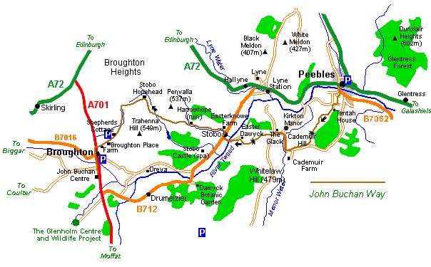
Stage 1: Peebles to Stobo (11 kms/6.5 miles)
In Peebles the route begins at Bank House by the mini roundabout at the west end of the High Street. From the roundabout you walk south (not along the High Street) and cross the River Tweed. After crossing the bridge bear right passing the traffic island with its 100 year old oak tree on your left and follow the road uphill for a short section before following the waymarkers to the left which lead you through the vennels to Chambers Terrace, Craigerne Lane and eventually Tantah House.
The path turns right here through a metal gate and runs uphill beside a wall. At the wall junction there is a wooden kissing gate which you pass through before taking the right most of three paths. This climbs to the right onto Cademuir Hill. For a while the path follows a power line and eventually reaches a fork where you take the left branch keeping the higher hills ahead of you and to the right. You will then see the summit of Cademuir Hill. At the next fork the path takes the right branch following a grass path around the hill.
At a junction of several paths you should keep ahead towards Cademuir Hill and a little further on fork left alongside a wall. The route starts to descend at this point but you may detour right and visit Cademuir's forts. The path then runs gently down past a Scots Pine plantation to the road linking Peebles with the Manor Valley. Just before the road the path turns and runs parallel to the tarmac as far as the entrance to Cademuir Farm.
Following the road beyond Cademuir Farm the route swings left and right past Milton Farm. Near Kirkton Manor the road crosses Manor Water and at the junction with the Manor valley road you turn left and follow the road to The Glack (another farm). Just beyond the farm the path turns right through a metal gate and goes uphill through a number of (often muddy) fields and over a number of stiles. The path climbs to the boundary between the Glack and Easter Dawyck crossing a dyke and another stile.
From there the path reaches a small summit and then heads downhill keeping outside of the fence line and then passes a small wood on the right. At this point there is a small burn to cross before joining a farm track and turning right. At the second gate you turn left to follow the fence. Just before another gate turn right over a stile and then turn left to follow the wall and fence to yet another stile.
Once over the stile the farm access road leads down to and crosses the River Tweed before reaching the main road. The path turns right and follows the main road at this point but you can also wait for a bus here to return to Peebles or continue to Broughton. Stobo Kirk is nearby and worthy of a visit.
Stage 2: Stobo to Broughton (11 kms/6.5 miles)
Passing the road to Stobo Kirk the path takes the next turning left signed Easterknowe Farm. Having past the cottages the path turns left over a stile following the Easton Burn. The track climbs gently towards Penvalla. At some sheep pens you pass through one gate and then cross the stile at a second gate. Where the path forks take the left path beside the plantation and up to the ruined cottage known as Harrowhope.
In front of the cottage the path turns left and crosses a footbridge before heading uphill to and through the pine trees. A ladder stile then crosses a dyke again with the summit of Penvalla directly ahead. The grassy track continues to climb the flank of Penvalla, then bends right and follows an old track round the hill and down towards the Hopehead Burn. Having crossed the burn the path climbs once again to join the main track and turns right up to Stobo Hopehead.
Before the house the track turns left and at the gathering shed goes left up a rough path on open hill with the Well Burn below to the right. A little further the path climbs towards a gap in the hills. It passes a hexagonal stone stell then later takes a left fork aiming for a kissing gate at the low point of the saddle. About 250 metres beyond the gate the path goes left and begins the descent to Broughton. Crossing the burn the path climbs slightly again giving fine views across to Culter Fell and Tinto Hill.
the path descends to the another kissing gate and the walkers' car park and from there follows the Broughton Place access path, past Broughton Place Gallery itself and down to the main A701. At the main road turn left and walk into and through Broughton village eventually reaching the John Buchan Centre at the south end of the village.
More Information
A leaflet providing more detailed information about the walk and places of interest on the walk is available from Peebles Tourist Information Centre in Peebles High Street.
| Top |

Broughton, by BIGGAR, Scottish Borders ML12 6JF
Telephone: 01899-830408 - Fax: 01899-830408
E-Mail: info@glenholm.co.uk